Saturday, June 4 was the start of my two week road trip through the volcanic Cascade country of the Pacific Northwest to attend the Travel Blog Exchange annual conference — #TBEX11 in Vancouver, British Columbia, Canada. Hopefully the trip will get more exciting than Day 1.
MilePoint 0.0 – Rain has fallen through most of the night in Monterey, California. A full-scale rain storm is rare in June in this part of California. How rare is it? Since 1849 in San Francisco, there have been four times the entire month of June had rainfall over one inch in accumulation. An inch of rain fell on June 4 in six hours breaking the 77-year old record for rain in San Francisco.
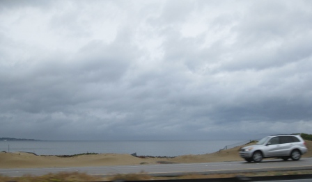
MilePoint 11.2 – Car overturned in the grassy median beside Highway 1 between artichoke fields of Castroville, California. Most drivers are doing 70 mph with no lights on and the roads are puddled with water. Physics trumps stupidity.
MilePoint 96  – Driving Interstate 680 with blind faith in white out conditions. Road spray creates a mist obscuring everything more than 100-feet ahead. Repeatedly I see arterial spray shoot up and over the barrier from the other side of the freeway as cars drive through puddled water.  Phoebe Hearst, WR’s mommy, would have thought this is Pleasanton in January rather than June with 57 degrees and heavy rain.
MilePoint 131 – The Benicia Bridge toll going north is $5. This bridge certainly hasn’t the view or beauty of the Golden Gate. Driving 580 from Dublin to Tracy and I-5 would bypass the $5 toll, but take $10 more in gas.
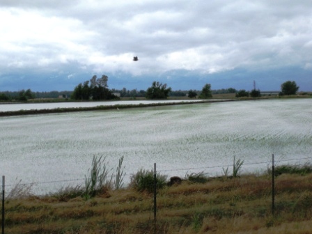
MilePoint 200 – Driving through the rice fields of the northern Sacramento Valley as the rain finally subsides to an intermittent sprinkle. I bet you didn’t realize California actually exports rice to Asia. Half a million acres of rice fields are within 100 miles of Sacramento. I pulled off I-5 to snap a photo and watched a Great Egret fly off into the mist. Obviously the blurry bird in my photo is not white or as big as a great egret.
Â
MilePoint 316 – Redding, California is nestled at the base of the Cascade foothills and is the northernmost city in the Sacramento Valley. This is where I-5 ends its 450 miles of flat terrain along the big Central Valley of California. The town is more geographically beautiful than I recall. The absence of a typical sweltering June afternoon when the temperature would normally be around 98 this time of year gives the appearance of a comfortable living location. This is typically among the sunniest locations in the U.S.
No sun today though. Rain in June just messes with our California sensibilities.
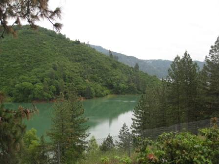
MilePoint 326 – Shasta Lake is at capacity this year. This lake is the largest reservoir in California and helps keep those rice paddies moist in summer and central valley lawns green.
Â
This lake area is big on houseboat rentals in the summer. Shasta Lake is the third largest lake in California.
The winding road through these mountain stretches is a welcome relief from the flat central valley. A pot of tea I had for lunch at a Chinese Restaurant in Fairfield is keeping me awake.
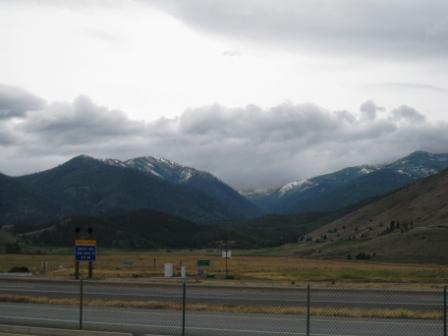
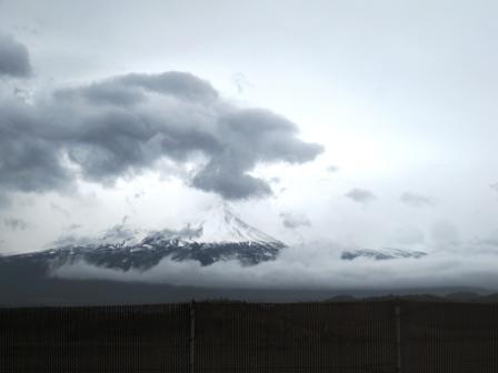
MilePoint 389 – After dropping down into sage country I pull over at a rest stop. It is feeling rather cool when I get out of my car to snap a photo of Mount Shasta. Weed is a town in the Shasta Valley sagebrush steppe of Siskiyou County. This valley divides the volcanic Cascade Range to the east from the glacial carved valleys of the Klamath Mountains to the west.
The wind is blowing fiercely cold off the snowy mountains. Still miles to go before I reach Oregon. And miles to go before I sleep.
Here is a photo of Mount Shasta on my last time through the area in November 2008.
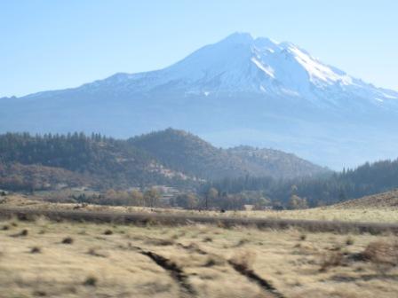
Mount Shasta is the second highest peak in the Cascade Range.  Mount Rainier, Washington at 14,411 ft. is a couple hundred feet higher. Prominence is a mountain term that describes how much higher a peak is compared to adjacent mountains and valleys. Mount Shasta is in the top 100 prominent mountains in the world at 9,822 ft., and Mount Rainier is #21 in the world at 13,211 ft.Â
Here is Mount Shasta on June 4, 2011.
MilePoint 433 – Crossed the California border. There is no large ‘Leaving California’ sign, although there is a small ‘Welcome to Oregon’ sign. Amazingly I only traversed the northern half of the state. Reaching Mexico from Monterey on Interstate 5 is 457 miles south. I tried to snap a photo of the I-5 Siskiyou Summit marker at 4,310 ft., a couple of miles inside Oregon and the highest point on Interstate 5. My camera only captured the ‘ou’ in the sign. The travails of snapping photos at 60 mph.
MilePoint 449 – Ashland, Oregon is home to the Oregon Shakespeare Festival. I’ve never been to the town to see a play, although I did stay at the Holiday Inn Express Ashland on my last drive through the area back in 2008 on a Priority Club 5,000 points PointBreaks night. The rate Saturday night June 4 was around $150.
MilePoint 462 – Medford, Oregon is home to all the chain motels and my resting place for the night. Tip for travelers is pick up the roadside motel coupon book at gas station stops. Holiday Inn, Homewood Suites, Hampton Inn and all the Marriotts were well over $100 per night.
The coupon brought the rate down from $80 to $50 for the Ramada and Quality Inn motels in Medford. Choice Privileges elite members even get free night promotion credit for rates booked using coupons. I didn’t pick up the coupon book, even though I told myself to do that for the last three hours of my drive.
Instead I sat in the lobby of the Ramada Medford and used their computer to book a Wyndham Rewards night at 14,000 points. Those points cost about $45 in last month’s Discover America sale.
Ultimately the redeemed points were not used wisely from a Loyalty Traveler advice viewpoint, but from a Loyalty Traveler business viewpoint I learned that a hotel night can be booked instantly through Wyndham Rewards. I redeemed my points using the Ramada lobby computer and stepped over to the reception desk and picked up my room key.
Pretty cool.

8 Comments
Comments are closed.